The Program
Four to six drill holes are planned on four new, and separate magnetic anomalies derived from the recently completed drone survey. Drilling should take approximately six weeks to complete, with assay data from geochemical sampling expected by July, if not June.
The exploration camp is once again fully established on private land at Otter Rapids located just 23 km southeast of the property. The camp is serviced by
The Targets
The program has two components, illustrated in Figures 1 and 2 respectively:
- Figure 1. The first four holes of the program will test the new AS magnetic highs derived from the recently completed, ultra- high resolution drone magnetic survey. They are located on the eastern flank of the gravity anomaly which was the focus of drilling in 2020 and 2021;
- Figure 2. Plan map and cross-section showing the 3D MVI inversion of the regional magnetic data which covers the H-K complex. The two holes planned for the second half of the program are shown on both map and section; they target MVI anomalies located in the central core and southern margin of the complex, some 2-3 km to the south of the previous drilling.
This is the company’s third reconnaissance drill program at H-K. In 2020, VR discovered a carbonate-fluorite hydrothermal breccia system which comes to bedrock surface and has more than 600 metres of vertical extent. It is hosted within, and is overprinted by ultra-high temperature, sulfide-bearing calc-potassic alteration. Follow-up drilling in 2021 intersected up to 299 m of rare earth elements and critical metals, and importantly, confirmed the presence of elevated gold along controlling structures.
By using the new AS magnetic anomalies derived from the new drone airborne survey as an indication of higher concentrations of hydrothermal magnetite, the objective of this third drill program is twofold:
- Test the new AS magnetic peaks immediately to the east of VR’s previous drilling for copper and gold, and/or, critical metals in higher concentrations than those intersected in 2020 and 2021;
- Test the central core and southern rim of the H-K complex for new centers of copper-gold breccia; neither target has been previously drilled.
From VR’s CEO, Dr.
To be clear, our drilling remains early-stage for a complex of this size. The point of Figure 1 is to emphasize that we have only just started to identify, understand and explore the specific controls on the various styles of mineralization intersected to date in the northern part of the complex. The new AS magnetic anomalies that we plan to drill are potentially the center of the hydrothermal breccia system discovered in our initial drilling. The point of Figure 2 is simply to make clear just how much larger the southern MVI inversion anomaly located on the south rim of the H-K complex is. It has never been previously drilled.
Given the intensity of hydrothermal brecciation, sulfide alteration and critical metal mineralization that we have intersected to date at H-K, we are excited to see what the four new drone-magnetic targets deliver in drill core in this next round of drilling. Indeed, this program will give us our first look across the breadth of the 4-6 km complex, and we look forward to providing further updates as our drilling advances.”
Background
Hecla-Kilmer (“H-K”) is a large and multiphase alkaline intrusive complex with carbonatite. It is 4 – 6 km in size, Proterozoic in age, and was emplaced along the western margin of the crustal-scale
A shallow, six-hole diamond drill program was completed in 1970 as part of a regional base metal exploration program by Ashland Oil and Elgin Petroleum. One hole was abandoned, and a scant 854 m were completed in total in the other five holes, all on magnetic highs in the outer concentric zones of the complex. No geochemical sampling or data are reported.
The opportunity for VR is to be the first company to apply modern IOCG and carbonatite mineral deposit models to explore the multiphase H-K complex and hydrothermal breccia system as a whole, and to use new exploration technologies not previously available when the historic drilling was done.
VR completed the first airborne EM survey over H-K in June, 2020, using the state-of-the-art VTEM+ system of
VR completed four drill holes for a total of 1,971 m in October, 2020, targeting the northern MVI (magnetic inversion) anomaly at H-K. In October, 2021, the Company followed up that drilling with the completion of 5 additional holes for a total of 2,604m, targeting the high contrast, 3.5 mGal gravity anomaly that is co-spatial with, but slightly offset from the MVI magnetic anomaly. Fluorite-carbonate hydrothermal breccia was discovered, coming to surface and hosted in a high temperature, sulfide-bearing calc-potassic alteration system, and containing broad intersections up to 299 m long of critical metals, with copper and gold locally. There are four different styles of mineralization evident: 1. REE’s and critical metals in hydrothermal breccia veined and brecciated carbonatite dykes (Holes 2, 4, 5, 8 and 9); 2. lithium mineralization in hydrothermal breccia (Holes 2 and 9); 3. copper sulfide in veinlets with iron and silica (Hole 2), and; 4. elevated hydrothermal gold related to syenite porphyry dykes (Holes 2, 6, 8 and 9).
A state-of-the-art, ultra- high resolution drone magnetic survey was completed in the fall of 2021, and expanded in March of 2022, in order to: 1. cover the entire complex at H-K, and; 2. identify vectors for how best to follow up on the hydrothermal breccia intersections with critical metals and gold in the first two drill programs. The final survey is 3.4 x 4.5 km in size, comprising 121 lines at both 25 and 50 m line-spacing for a total of 410 line-km. The survey produces a very high resolution of data because of the tight line spacing, the low “tree-top” flight altitude of just 30 metres above ground, and a computerized flight control paired with a new, very high sensitivity potassium-vapour magnetometer.
Going forward, the third drill program planned for the spring of 2022 will test new drone AS magnetic anomalies located immediately to the east of the sulfide-bearing breccia intersected in 2020 and 2021, and test the larger and more deeply rooted MVI magnetic anomalies located 2 – 3 km to the south in the central core and southern rim of the complex, and which have never been drilled before, period.
Technical Information
Summary technical and geological information for the Company’s various exploration properties is available at the Company’s website at www.vrr.ca.
VR submitted all drill core for GeologicAI XRF and SWIR scanning, and selected sawn drill core samples for geochemical assay to the
Technical information for this news release has been prepared in accordance with the Canadian regulatory requirements set out in National Instrument 43-101.
About the Hecla-Kilmer Property
The Hecla-Kilmer complex is located 23 km northwest of the
The H-K property is large. It consists of 224 mineral claims in one contiguous block approximately 6 x 7 km in size and covering 4,617 hectares. The property is owned 100% by VR. There are no underlying annual lease payments on the property, nor are there any joint venture or back-in interests. There is an industry-standard royalty attached to the property, including a buy-back provision in favour of VR.
Like the Ranoke property, H-K is located on provincial crown land, with mineral rights administered by the
About
VR is an established junior exploration company focused on greenfields opportunities in copper, gold and critical metals (TSX.V: VRR;
The Company continues its normal course of business in 2022 within the framework of modified exploration programs in response to the COVID-19 pandemic, with the goal of ensuring the health and safety of staff and project personnel.
ON BEHALF OF THE BOARD OF DIRECTORS:
“Michael H. Gunning”
____________________________
Dr.
President & CEO
For general information please use the following:
Website: www.vrr.ca
Email: info@vrr.ca
Phone: 604-262-1104
Forward Looking Statements
This press release contains forward-looking statements. Forward-looking statements are typically identified by words such as: believe, expect, anticipate, intend, estimate, postulate and similar expressions or those which, by their nature, refer to future events. Forward looking statements in this release include those related to the companies upcoming plans, such as “The new AS magnetic anomalies that we plan to drill are potentially the center of the hydrothermal breccia system discovered in our initial drilling”, and “VR evaluates new opportunities on an ongoing basis, whether by staking or acquisition.”
This news release contains statements and/or information with respect to mineral properties and/or deposits which are adjacent to and/or potentially similar to the Company’s mineral properties, but which the Company has no interest in nor rights to explore. Readers are cautioned that mineral deposits on similar properties are not necessarily indicative of mineral deposits on the Company’s properties.
Although the Company believes that the use of such statements is reasonable, there can be no assurance that such statements will prove to be accurate, and actual results and future events could differ materially from those anticipated in such statements. The Company cautions investors that any forward-looking statements by the Company are not guarantees of future performance, and that actual results may differ materially from those in forward-looking statements. Trading in the securities of the Company should be considered highly speculative. All of the Company’s public disclosure filings may be accessed via www.sedar.com and readers are urged to review these materials. Neither the
Figure 1. Shown schematically in dashed white lines are drill holes planned for 2022 to test the new AS magnetic highs derived from the recently completed, high resolution drone-based magnetic survey, and located in the eastern part of the gravity anomaly, the core of which was the focus of drilling in 2020 and 2021. https://www.globenewswire.com/NewsRoom/AttachmentNg/eb4c8801-1796-4a2c-b466-95539ce87f10
Figure 2a. Plan map with the 3D MVI magnetic inversion model superimposed on the RTP magnetic base map, both derived from the regional HighSense airborne magnetic survey in 1993. Shown are the locations of drill holes completed to date by VR, and those planned in follow-up for 2022. See Figure 1 for details of drilling planned for the northern MVI anomaly. See Figure 2b for an oblique, north-south cross-section through the MVI magnetic model. https://www.globenewswire.com/NewsRoom/AttachmentNg/81d4ffcb-bd73-480a-8c8f-e97d792ce169
Figure 2b. Oblique north-south cross section through the MVI magnetic anomaly shown on the plan map in Figure 2a. Shown are the drill holes completed by VR on the northern MVI magnetic anomaly in 2020 and 2021, and those planned for 2022 in the southern MVI anomaly (white traces). The MVI 3D inversion model is derived from the HighSense regional airborne magnetic survey in 1993. https://www.globenewswire.com/NewsRoom/AttachmentNg/6b5b98a6-6e15-4630-8425-b42bd1991cd1
Neither the

![]()
Figure 1

Shown schematically in dashed white lines are drill holes planned for 2022 to test the new AS magnetic highs derived from the recently completed, high resolution drone-based magnetic survey, and located in the eastern part of the gravity anomaly, the core of which was the focus of drilling in 2020 and 2021.
Figure 2a
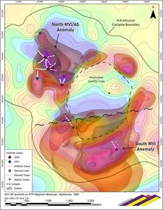
Plan map with the 3D MVI magnetic inversion model superimposed on the RTP magnetic base map, both derived from the regional HighSense airborne magnetic survey in 1993. Shown are the locations of drill holes completed to date by VR, and those planned in follow-up for 2022. See Figure 1 for details of drilling planned for the northern MVI anomaly. See Figure 2b for an oblique, north-south cross-section through the MVI magnetic model.
Figure 2b
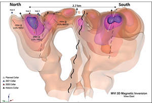
Oblique north-south cross section through the MVI magnetic anomaly shown on the plan map in Figure 2a. Shown are the drill holes completed by VR on the northern MVI magnetic anomaly in 2020 and 2021, and those planned for 2022 in the southern MVI anomaly (white traces). The MVI 3D inversion model is derived from the HighSense regional airborne magnetic survey in 1993.
2022 GlobeNewswire, Inc., source
