- 2,000m diamond drilling program to commence by the end of January to test new IP targets and Central Anomaly on major magnetic trends
- 54.5 line-kilometres of additional IP surveys to be completed on major target area in southern part of claims
Figure 1 is a map of the total magnetic intensity that shows the two major magnetic trends at Big Easy. The West Trend extends north-northeast for 19 km and it is likely the southerly extension of the Big Easy-Central Anomaly trend. The East Trend is approximately 2 km to the east and is parallel to the West Trend extending southwards for more than 20 km. Figure 2 is a closeup map showing the locations of the planned drill holes in the new IP chargeability anomalies on the Shoal Harbour Grid and the follow-up drilling on the Central Anomaly 5.5 km to the north. The modelled chargeability is within and follows the strong magnetic trends. Figure 3 shows the area of the planned additional IP survey lines.
Four (4) holes totalling 1,000 metres are planned to test significant chargeability anomalies on the Shoal Harbour Grid. These anomalies are associated with resistivity lows flanking the east and west contacts of a broad zone of higher resistivity. The east anomaly coincides with the Au-in-soil geochemical peak reported in the press release of
Qualified Person
Dr.
About
Please visit
For further information please contact:
| Chief Executive Officer | Vice-President | |
| (416) 360-8006 | (416) 360-8006 |
The CSE has not reviewed nor accepts responsibility for the adequacy or accuracy of this release. Statements in this release that are not historical facts are “forward-looking statements” and readers are cautioned that any such statements are not guarantees of future performance, and that actual developments or results, may vary materially from those in these “forward-looking statements”.
Table 1. Collar coordinates, orientation and length of diamond drill holes planned at Big Easy.
| DDH No. | Collar E (NAD83) | Collar N (NAD83) | Dip | Az | Length (m) |
| BE-21-01P | 709300 | 5340800 | -60 | 270 | 250 |
| BE-21-02P | 709150 | 5340500 | -60 | 270 | 250 |
| Be21-03P | 709861 | 5341759 | -60 | 270 | 250 |
| Be21-04P | 710754 | 5340526 | -60 | 90 | 250 |
| CENTRAL ANOMALY | |||||
| BE-21-33P | 709865 | 5346300 | -45 | 270 | 400 |
| BE-21-34P | 709930 | 5346300 | -45 | 270 | 400 |
| BE-18-32EXT | 710000 | 5346286 | -45 | 270 | 200 |
| 2,000 | |||||
| Holes will be NQ sized core. Dip and Azimuth are in degrees. | |||||
| Note hole names may change depending on the order the holes are drilled due to logistical considerations. | |||||
Figure 1: Plan Map of
https://www.globenewswire.com/NewsRoom/AttachmentNg/1c4a6288-8631-4482-bc05-8c366e003832
Figure 2: Plan map showing locations of significant chargeability anomalies and planned drill holes in the new IP target area in the Shoal Harbour Grid and in the Central Anomaly,
https://www.globenewswire.com/NewsRoom/AttachmentNg/a02ba32c-835d-4851-be2e-eca681d63893
Figure 3: Location of Additional IP Survey Lines on total field magnetics map, Sleigh Pond Grid,
https://www.globenewswire.com/NewsRoom/AttachmentNg/0fb7c7e4-ea78-4e6c-b06a-1438dc698049
PDF available: http://ml.globenewswire.com/Resource/Download/c1c6218d-917c-46f3-bdcf-4fb47b2d94db
![]()
Figure 1
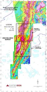
Plan Map of Big Easy Gold Project showing total field magnetics and major magnetic trends with locations of Figures 2 and 3, Big Easy Gold Project .
Figure 2
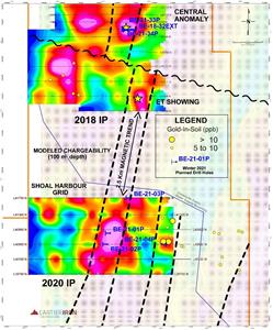
Plan map showing locations of significant chargeability anomalies and planned drill holes in the new IP target area in the Shoal Harbour Grid and in the Central Anomaly, Big Easy Gold Project .
Figure 3
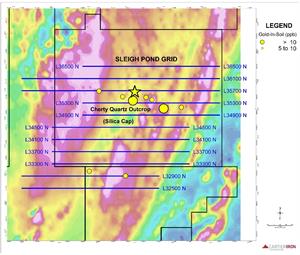
Location of Additional IP Survey Lines on total field magnetics map, Sleigh Pond Grid, Big Easy Gold Project .
2021 GlobeNewswire, Inc., source


