(via TheNewswire)

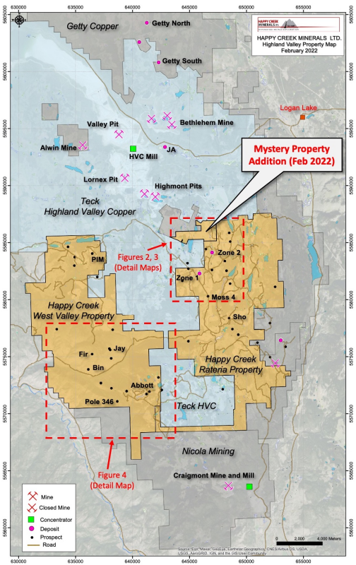
In addition, the TSX-V has approved the Purchase and Sale Agreement for the adjoining and highly prospective 438-hectare Mystery property, as announced on
During summer and fall 2021, Happy Creek collected over 2100 soil, stream silt and prospecting rock samples.
The 2021 field work was primarily focused on the northern part of the Rateria property, near the Company’sZone 2porphyry copper-molybdenum-silver-gold deposit (Figures 1, 2 and 3). Drilling by the Company at Zone 2 since its discovery in 2008 has returned consistently strong copper grades, with locally enhanced gold, silver and molybdenum values, over an area of 900 m by 600 m. Highlight drill intercepts include 105.5 m grading 0.37% Cu, 0.14 g/t Au, and 0.005% Mo in hole R17-05, 126 m grading 0.46% Cu, 0.10 g/t Au and 0.008% Mo in hole R08-05, and 5.0m grading 4.41% Cu, 0.21 g/t Au, 20.0 g/t Ag, 0.031% Mo and 6.86 g/t Re (rhenium) in R17-02.
Highlights
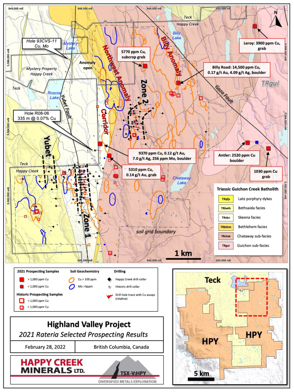
Three new multi-kilometre copper-molybdenum targets were identified through soil sampling and prospecting. These new targets, namedBilly, CorridorandNorthwest, have received minimal past exploration or drilling (Figures 1 to 4).
Prospecting within the new soil anomalies and elsewhere on the very large property has discovered several new areas of mineralization, including at
Billy Road where a grab sample of float returned1.45% Cu and 0.167 g/t Au.The newly acquired 438-hectareMystery propertycovers potential extensions of known mineralization (Figures 1 and 2) and a promising porphyry Cu-Mo target that was partly tested with three relatively short drill holes by Hudson Bay Exploration and Development (Hudbay) in 1993. Hole 93CVS-11 is reported to have intersected a very broad (230 m wide), intense porphyry alteration zone with encouraging copper and molybdenum values to the last sample near the end of the hole.
The Company holds a multi-year permit for over 100 drill sites and related work. Follow-up archaeology and environmental studies were completed on over 30 proposed drill sites by First Nations consultants in 2021 and planning is underway for the 2022 exploration program.
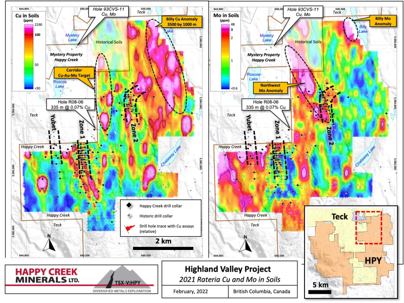
A total of 1907 soil samples were collected on the Rateria soil grid and resulted in the discovery and delineation of several multi-kilometre copper and molybdenum anomalies (Figure 2). Anomalous copper values range from 100 ppm (84thpercentile) 2190 ppm Cu. Anomalous molybdenum values range from 3 ppm (90thpercentile) to 48 ppm Mo.
The new anomalies have had minimal past exploration but appear much larger and stronger than soil anomalies associated with known mineralization. This is best demonstrated by the relatively small Cu and Mo anomalies over the Zone 1 Cu-Ag deposit and the Zone 2 Cu-Mo-Ag-Au deposit. Both of these deposits have drill holes with mineralization intersected beneath glacial till at the bedrock surface.
The impressive
TheNorthwest Molyanomaly is strong, with values of molybdenum-in-soil ranging from 3 to 23.5 ppm Mo, and large, with dimensions of 2500 m by 500 m. It partly overlies the Zone 2 Cu-Mo-Ag-Au deposit and extends northwesterly onto the newly acquired Mystery property where it remains open (Figure 2). Scattered values of high copper in soil also fall within the molybdenum trend. This anomaly has very good potential for discovery of new mineralization along the untested two-kilometres between the Zone 2 deposit and historic Mystery hole 93CVS-11, described below.
TheCorridor Copper-Moly-Goldtarget is located 1000 m west of Zone 2 (Figure 2). The new soil results demonstrate a series of discontinuous Cu soil anomalies that trend northerly for 2 km onto the Mystery property, where it merges with the Northwest moly anomaly described above. Two 2021 prospecting rock samples returned strong Cu (to 9370 ppm) with anomalous Mo and Au values, as described below. Previous drilling has not fully tested this target.
Several other strong but smaller areas of Cu and Mo in soil are also present and have received scant prospecting or drilling.
Rock Sampling and Targeting
Nineteen prospecting rock samples were collected across the property in 2021, mainly from bedrock exposures and road cuts (Table 1, Figures 3 and 4). Twelve of the 17 prospecting samples returned copper values ranging from 1000 to 14,500 ppm (1.45%) Cu. Three rock samples in the Rateria area were also anomalous for Au (120 to 142 ppb) and one carried 256 ppm Mo.2
A float grab sample (#4899) from the new
In theCorridortarget, about 1000 m west of Zone 2 deposit, two prospecting samples and a series of discontinuous Cu-in-soil anomalies suggest the potential for a new, parallel mineralized trend. A 15 cm chip of a boulder contains9370 ppm Cu, 256 ppm Mo, 120 ppb Au and 7 ppm Ag, and a grab from bedrock contains5310 ppm Cu and 142 ppb Au(Figure 3).2Previous drilling has not fully tested this target, with R08-06, intersecting334.66 m grading 0.07% Cu(Figures 2 and 3), that confirms the potential for very broad porphyry mineralization here.
In the
Previous induced polarization (IP) geophysical surveys by Happy Creek and others had identified promising chargeability and resistivity features within these target areas. Limited additional surveying is warranted to expand the IP coverage prior to drilling.
Mystery Property
Happy Creek has now received TSX-V approval for the purchase of a 100 per cent interest in the adjoining Mystery Property, as announced on
The Mystery area has been explored by various parties over the years most notably
“An intrusive complex was intersected in hole 93CVS-11 with at least three varieties of porphyry displaying varying degrees of alteration. In the best hole (93CVS-11) intense pervasive hydrothermal alteration displays a complex sequence of events. Mineralization is dominantlychalcocite-bornite-quartz veining, with the best intercepts containing 1.36% copper(and 11.8 g/t Ag)across 3 metres, in local high-grade mineralization. Lower copper levels are more typical of the mineralization and include a 12 metre interval of 2664 ppm(0.27%)Cu(with elevated molybdenum and silver).Hole 93CVS-11 intersected about 230 metres of moderate to intense pervasive sericite altered rock, punctuated by up to 40 metre wide K-spar altered intervals. Sericite alteration is complicated by the presence of a later, strong sericite overprint (sericite II).(S.G. Enns, BC Property File #PF804381).1
Review of Hudson Bay drill logs indicate that the alteration and mineralization is present almost to the very the end of the hole at 300.5 m.1Happy Creek intends to immediately prepare this target for drilling with geology, soils and limited IP work.
Work Plans, Permitting, and COVID Safety
In spring and early summer of 2022, Happy Creek will optimize the opportunity for successful drill testing at the various targets outlined above through additional geological studies, prospecting, soils and IP geophysical surveys.
Happy Creek holds two exploration permits from the Government of
The Company operates with the principles and guidelines set out for COVID-19 that are established by provincial health and safety authorities to protect workers and the communities in which the Company operates.
Indigenous Communities
About
Happy Creek is focused on making new discoveries and building resources in proximity to infrastructure on its 100-percent-owned portfolio of diversified metals projects in
About
The 100-percent-owned
More information on the Company’s projects can be found on the Company’s website at www.happycreekminerals.com.
Quality Assurance / Quality Control Procedures
Samples were shipped to, prepared, and analyzed at
Qualified Person Statement
The technical and scientific contents of this release have been prepared, verified and approved by
References and Disclosure
1 The Qualified Person has not completed sufficient work to verify the historic information on the Property, particularly in regard to historical drill results. However, the Qualified Person believes that drilling and analytical results were completed to industry standard practices. The information provides an indication of the exploration potential of the Property but may not be representative of expected results.
2Grab and chip samples are selective by nature and the values reported may not be representative of the entire mineralized zone.
3Mineralization hosted on adjacent and/or nearby properties is not necessarily indicative of mineralization hosted on the Company’s property.
On behalf of the Board of Directors,
“Peter Hughes”
President and Chief Executive Officer
FOR FURTHER INFORMATION, PLEASE CONTACT:
Office Phone: (604) 662-8310
Email: phughes@happycreekminerals.com
Neither the
The reader is cautioned that results or information from an adjacent property does not infer or indicate similar results or information will or does occur on the subject property. Historical information from the subject or adjacent property cannot not be relied upon as the Company’s QP, a term which was created and defined under NI-43-101, has not prepared nor verified the historical information.
This press release contains "forward-looking information" within the meaning of applicable securities laws, including statements that address capital costs, recovery, grade, and timing of work or plans at the Company’s mineral projects. Forward-looking information may be, but not always, identified by the use of words such as "seek", "anticipate", “foresee”, "plan", "planned", "continue", "expect", “thought to”, "project", "predict", "potential", "targeting", "intends", "believe", “opportunity”, “further” and others, or which describes a goal or action, event or result such as "may", "should", "could", "would", "might" or "will" be undertaken, occur or achieved. Statements also include those that address future mineral production, reserve potential, potential size or scale of a mineralized zone, potential expansion of mineralization, potential type(s) of mining, potential grades as well as to Happy Creek’s ability to fund ongoing expenditure, or assumptions about future metal or mineral prices, currency exchange rates, metallurgical recoveries and grades, favourable operating conditions, access, political stability, obtaining or renewal of existing or required mineral titles, licenses and permits, labour stability, market conditions, availability of equipment, accuracy of any mineral resources, anticipated costs and expenditures. Assumptions may be based on factors and events that are not within the control of Happy Creek and there is no assurance they will prove to be correct. Such forward-looking information involves known and unknown risks, which may cause the actual results to materially differ, and/or any future results expressed or implied by such forward-looking information. Additional information on risks and uncertainties can be found within Financial Statements, Prospectus and other materials found on the Company’s SEDAR profile atwww.sedar.com. Although Happy Creek has attempted to identify important factors that could cause actual actions, events or results to differ materially from those described in forward-looking information, there can be no assurance that such information will prove to be accurate as actual results and future events could differ materially from those anticipated in such statements. Happy Creek withholds any obligation to update or revise any forward-looking information, whether as a result of new information, future events or otherwise, unless required by law.
Click Image To View Full Size
Figure 1.
Click Image To View Full Size
Figure 2. Soil geochemistry maps for copper and molybdenum of northern Rateria property. Zone 1 Cu-Ag, Zone 2 Cu-Au-Mo and Yubet Cu deposits are also shown by heavy dashed line.
Click Image To View Full Size
Figure 3. Selected rock samples in the northern Rateria property, in relation to known deposits and targets.
Click Image To View Full Size
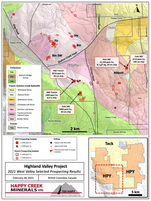
Figure 4. Selected rock samples in the southern
Table 1. 2021 Prospecting
Target | Sample # | Easting | Northing | Cu (ppm) | Mo (ppm) | Ag (ppm) | Au (ppb) | Sample type (width) |
Rateria West of Zone 2 | 4896 | 646374 | 5583415 | 9370 | 256 | 7.0 | 120 | Boulder - chip (15 cm) |
Rateria SAS | 4897 | 646636 | 5583070 | 5310 | 2 | 3.6 | 142 | Outcrop - grab |
Rateria Zone 2 NE | 4898 | 647673 | 5585664 | 5770 | 1 | 3.6 | 22 | Outcrop - chip (15 cm) |
Rateria Billy Lake road | 4899 | 648634 | 5585177 | 14,500 | 2 | 4.1 | 167 | Outcrop- grab |
4900 | 650845 | 5586813 | 3900 | 2 | 1.1 | 11 | Outcrop - chip (20 cm) | |
4465 | 650903 | 5583458 | 836 | 1 | 0.4 | 2 | Outcrop- grab | |
4466 | 650635 | 5583446 | 2520 | 1 | 1.1 | 19 | Outcrop - chip (25 cm) | |
4467 | 651238 | 5583279 | 1,030 | 1 | 0.4 | 1 | Outcrop- grab | |
WV Abbott South | 307501 | 641385 | 5570049 | 186 | 2 | 0.5 | 1 | Outcrop - chip (3.5 m) |
WV Abbott South | 307502 | 641389 | 5570049 | 670 | 1 | 1.1 | 5 | Outcrop - chip (100 cm) |
WV Pole 346 | 307503 | 638636 | 5571244 | 5460 | 1 | 0.4 | 16 | Outcrop - chip (50 cm) |
WV Pole 383 | 307504 | 642277 | 5573174 | 4170 | 1 | 2.7 | <1 | Outcrop - chip (100 cm) |
WV Pole 383 | 307505 | 642277 | 5573174 | 305 | 1 | 0.2 | <1 | Outcrop - chip (7.0 m) |
WV Pole 383 | 307506 | 642277 | 5573174 | 11150 | 1 | 8.1 | 5 | Outcrop - chip (50 cm) |
WV Abbott NW trenches | 307507 | 638115 | 5572164 | 8710 | 6 | 1.8 | 9 | Outcrop - chip (50 cm) |
WV Abbott NW trenches | 307508 | 638121 | 5572176 | 1405 | 2 | 0.6 | <1 | Outcrop - chip (6.0 m) |
WV Abbott NW trenches | 307509 | 638404 | 5572175 | 85 | 2 | 0.1 | <1 | Outcrop - chip (30 m) |
WV Abbott NW trenches | 307510 | 638471 | 5572114 | 652 | 1 | 0.3 | <1 | Outcrop- grab |
WV Abbott NW trenches | 307511 | 638590 | 5572190 | 29 | 3 | 0.1 | <1 | Outcrop- grab |
Copyright (c) 2022 TheNewswire - All rights reserved.
Copyright (c) 2022 TheNewswire - All rights reserved., source