Figure 1: Location of Algarrobo and Salvadora projects.
https://www.globenewswire.com/NewsRoom/AttachmentNg/805f014d-1e7a-449e-920e-50666914d239
La Salvadora iron oxide copper gold (“IOCG”) project, is located approximately 2 hours drive north from Nobel’s Algarrobo project. La Salvadora occurs in the vicinity of the large Manto Verde (Anglo American) and
- Area of SLVA-RC-0002 which intersected 72 meters grading 1.21% copper and 0.21 g/t gold. This area is wide open for expansion.
- A second distinct buried magnetic anomaly approximately 1 kilometer to the south with only a single drill hole in it (SLVA-RC-0010) which intersected 20 meters grading 0.6% copper and 0.15g/t gold at shallow depths.
- A series of drill holes to evaluate the extension of the copper oxide zone that extends at least 750 meters along a northwest trending mineralized structure.
All the holes drilled to date by
The first five drill holes targeted the depth and lateral extensions below previously identified copper oxide mineralization at surface in the vicinity of historical RC drill hole SLVA-RC-0002 (see news release dated
According to
According to
Figure 2: Location map showing the
https://www.globenewswire.com/NewsRoom/AttachmentNg/7800e6d4-d317-469c-afdd-a757bd899dee
Figure 3: Location of the two target areas and drill holes at
https://www.globenewswire.com/NewsRoom/AttachmentNg/78f2bb99-c5c1-42f5-8170-178444571070
Figure 4: Chargeability map of a portion of La Salvadora showing SLVA-RC-0010 on the southern magnetic-Chargeability anomaly. The series of white historical RC drill holes show the distribution of near-surface copper oxide mineralization.
https://www.globenewswire.com/NewsRoom/AttachmentNg/cb923671-d977-402a-81ad-aa58ee71dc8f
Note the Company has not seen QA/QC data nor are there RC chips preserved from the historical RC drill holes SLVA-RC-0002 or SLVA-RC-0010 results. Readers are cautioned that these potential grades are from single drill holes in otherwise untested mineralized zones and there has been insufficient exploration by the Company or its qualified person at La Salvadora to define a mineral resource or mineral reserve estimate and it is uncertain whether further exploration will result in these targets being delineated as a mineral resource or mineral reserve.
| Assay Summary | ||||||||||
| Holes | North | East | From (m) | To (m) | Best Cu Interval (including) | Gold (g/Tn) | Copper (%) | Cobalt (%) | Silver (g/Tn) | |
| SAL21-001 | 7113277 | 385004 | 149.00 | 150.00 | 50m@0.57%Cu | 12m@0.98%Cu | 0.286 | 2.29 | 0.02 | 1.70 |
| 150.00 | 151.00 | 0.177 | 1.09 | 0.01 | 1.10 | |||||
| 151.00 | 152.00 | 0.119 | 0.76 | 0.01 | 0.90 | |||||
| 152.00 | 153.00 | 0.137 | 0.64 | 0.01 | 0.80 | |||||
| 153.00 | 154.00 | 0.096 | 0.49 | 0.01 | 0.80 | |||||
| 154.00 | 155.00 | 0.026 | 0.24 | 0.01 | 0.60 | |||||
| 155.00 | 156.00 | 0.177 | 1.49 | 0.01 | 1.30 | |||||
| 156.00 | 157.00 | 0.28 | 1.64 | 0.00 | 1.20 | |||||
| 157.00 | 158.00 | 0.044 | 0.42 | 0.00 | 0.60 | |||||
| 158.00 | 159.00 | 0.288 | 1.52 | 0.01 | 1.60 | |||||
| 159.00 | 160.00 | 0.061 | 0.52 | 0.01 | 0.80 | |||||
| 160.00 | 161.00 | 0.078 | 0.56 | 0.01 | 0.90 | |||||
| 171.00 | 172.00 | 14m@0.76%Cu | 0.144 | 1.27 | 0.01 | 1.00 | ||||
| 172.00 | 173.00 | 0.054 | 1.07 | 0.00 | 0.60 | |||||
| 173.00 | 174.00 | 0.039 | 0.31 | 0.01 | 0.60 | |||||
| 174.00 | 175.00 | 0.018 | 0.27 | 0.01 | 0.50 | |||||
| 175.00 | 176.00 | 0.142 | 1.01 | 0.01 | 0.80 | |||||
| 176.00 | 177.00 | 0.203 | 1.32 | 0.02 | 1.20 | |||||
| 177.00 | 178.00 | 0.1 | 0.90 | 0.01 | 1.00 | |||||
| 178.00 | 179.00 | 0.034 | 0.59 | 0.01 | 0.25 | |||||
| 179.00 | 180.00 | 0.042 | 0.55 | 0.01 | 0.25 | |||||
| 180.00 | 181.00 | 0.156 | 1.19 | 0.01 | 0.25 | |||||
| 181.00 | 182.00 | 0.025 | 0.44 | 0.00 | 0.25 | |||||
| 182.00 | 183.00 | 0.028 | 0.26 | 0.00 | 0.25 | |||||
| 183.00 | 184.00 | 0.041 | 0.85 | 0.01 | 0.25 | |||||
| 184.00 | 185.00 | 0.044 | 0.65 | 0.01 | 0.25 | |||||
| SAL21-002 | 7113243 | 384965 | 132.00 | 133.00 | 2m@0.58%Cu | 0.026 | 0.21 | 0.00 | 0.25 | |
| 133.00 | 134.00 | 0.226 | 0.95 | 0.00 | 0.25 | |||||
| 154.00 | 155.00 | 2m@0.52%Cu | 0.132 | 0.43 | 0.01 | 0.80 | ||||
| 155.00 | 156.00 | 0.129 | 0.61 | 0.02 | 0.60 | |||||
| 208.00 | 209.00 | 2m@0.45%Cu | 0.007 | 0.13 | 0.00 | 0.25 | ||||
| 209.00 | 210.00 | 0.114 | 0.78 | 0.01 | 0.50 | |||||
| SAL21-004 | 7113334 | 384971 | 154.00 | 155.00 | 4m@0.26%Cu | 0.059 | 0.327 | 0.007 | ||
| 155.00 | 156.00 | 0.009 | 0.205 | 0.003 | ||||||
| 156.00 | 157.00 | 0.021 | 0.158 | 0.003 | ||||||
| 157.00 | 158.00 | 0.027 | 0.33 | 0.008 | ||||||
| 182.00 | 183.00 | 2m@0.26%Cu | 0.012 | 0.2 | 0.006 | |||||
| 183.00 | 184.00 | 0.043 | 0.326 | 0.011 | ||||||
| 206.00 | 207.00 | 2m@0.34%Cu | 0.092 | 0.196 | 0.005 | |||||
| 207.00 | 208.00 | 0.103 | 0.49 | 0.012 | ||||||
| SAL21-005 | 7113369 | 384935 | 139.00 | 140.00 | 15m@0.49%Cu | 10m@0.65%Cu | 0.341 | 2.467 | 0.009 | |
| 140.00 | 141.00 | 0.036 | 0.296 | 0.002 | ||||||
| 141.00 | 142.00 | 0.037 | 0.39 | 0.004 | ||||||
| 142.00 | 143.00 | 0.053 | 0.358 | 0.005 | ||||||
| 143.00 | 144.00 | 0.031 | 0.243 | 0.003 | ||||||
| 144.00 | 145.00 | 0.158 | 0.522 | 0.043 | ||||||
| 145.00 | 146.00 | 0.173 | 0.879 | 0.01 | ||||||
| 146.00 | 147.00 | 0.067 | 0.389 | 0.006 | ||||||
| 147.00 | 148.00 | 0.09 | 0.606 | 0.006 | ||||||
| 148.00 | 149.00 | 0.015 | 0.303 | 0.002 | ||||||
| SAL21-006 | 7112534 | 385144 | *Pending results | |||||||
Algarrobo Update
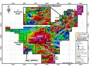
The geophysical target drill program started on the Northeast Target at Algarrobo due to the logistical difficulties accessing the central and southwest areas of the large Central geophysical anomaly where access roads were constructed and water holding tanks had to be installed (see Figure 5 below).
The Company has now completed a total of six holes on the geophysical target follow up of which assay results have been received for the first two (AGL21-046 and AGL21-47) from the Northeast Target. Both drill holes intersected wide sections of potassic altered intrusive rocks with varying amounts of disseminated and veinlets of pyrite, pyrrotite, magnetite and minor chalcopyrite over approximately 200 meters.
Assay results have yet to be received for the four holes which have been drilled into the main part of the Central anomaly and the Southwest anomaly. Drilling on these targets presented an unexpected challenge in that the thickness of sand dunes in this part of the property increased to 150-180 meters thick as compared to less than 5 meters in the northeast part of the property. All four holes intersected potassic alteration including biotite breccias with pyrite, pyrrotite, magnetite and minor chalcopyrite. In addition, a 3.0m quartz-tourmaline pyrite-chalcopyrite breccia was intersected in the south Gloria target located near the edge of the large magnetic anomaly.
The alteration observed on this target appears to outline a large area of porphyry style alteration and mineralization covering 3.0 by 5.0 kilometers that warrants further testing. Holes drilled to date are spaced at 1 kilometer apart in the central zone and 2 kilometers to the edges from each other leaving significant room for additional exploration.
All drill holes drilled to date have been sampled for mineralogical analysis work to assist in defining the alteration pattern and define vectors towards potentially more strongly mineralized parts of the system. Given the large size of the alteration zone, the observed weak mineralization and the high number of copper bearing veins associated with the artisanal mines, and the large spacing between drill holes done so far, the Company feels that additional exploration drilling is warranted on this target. The alteration, mineralization and plethora of mineralized veins are all characteristics commonly associated with large porphyry copper systems. The mineralogical analysis will provide important information for better targeting future drilling.
| Extensive Alteration Zones | |||
| Holes | North WGS 84 | East WGS84 | Description |
| ALG21-046 | 7009005 | 343926 | 205m, magnetite dissemination, minor chalcopyrite-pyrite, early veins with quartz pyrite and chalcopyrite |
| ALG21-047 | 7008124 | 343639 | 194m, magnetite dissemination, minor chalcopyrite-pyrite, early veins with quartz pyrite, pyrrhotite and chalcopyrite |
| ALG21-048 | 337498 | 7004400 | 315m, magnetite dissemination, minor chalcopyrite-pyrite-pyrrhotite, quartz pyrite, pyrrhotite and chalcopyrite veins. |
| ALG21-049 | 338506 | 7004625 | 250m, magnetite dissemination, minor chalcopyrite-pyrite-pyrrhotite, quartz pyrite, pyrrhotite and chalcopyrite veins. |
| ALG21-050 | 335500 | 7003107 | 370m, magnetite dissemination, minor chalcopyrite-pyrite-pyrrhotite, quartz pyrite, pyrrhotite and chalcopyrite veins. |
Figure 5: Algarrobo geophysical target drilling, drill hole location map.
https://www.globenewswire.com/NewsRoom/AttachmentNg/44d58d44-3740-46fa-8972-74a51af6f53b
| Summary Drill Results | ||||||||||
| Holes | Azimuth (°) | Dip (°) | Depth (m) | From (m) | To (m) | Best Cu Interval | Gold (g/Tn) | Copper (%) | Cobalt (%) | Silver (g/Tn) |
| ALG21-046 | 180 | -70 | 300.00 | 191.00 | 191.50 | 0.04 | 0.28 | 0.05 | 1.1 | |
| 191.50 | 192.00 | 1.5m@0.97%Cu | 0.19 | 1.30 | 0.06 | 2.6 | ||||
| 192.00 | 192.50 | 0.50 | 0.76 | 0.03 | 2.3 | |||||
| 192.50 | 193.00 | 0.03 | 0.84 | 0.01 | 3.7 | |||||
| 193.00 | 193.50 | 0.11 | 0.20 | 0.01 | 1.9 | |||||
| ALG21-047 | 180 | -70 | 506.05 | 309.90 | 310.40 | 1.5m@1.22%Cu | 0.13 | 2.37 | 0.07 | 6.2 |
| 310.40 | 311.40 | 0.008 | 0.05 | 0.00 | - | |||||
Qualified Person
The scientific and technical information in this news release has been reviewed and approved by Mr.
About
For further information, please contact:
Chief Executive Officer
info@nobel-resources.com
www.nobel-resources.com
Cautionary Note Regarding Forward-looking Information
This press release contains “forward-looking information” within the meaning of applicable Canadian securities legislation. Forward-looking information includes, without limitation, regarding the prospectivity of each of the Algarrobo project and the La Salvadora project (collectively, the “Projects”), the mineralization of the Projects, the Company’s ability to explore and develop the Projects, timing of the Company receiving drill permits; access to drilling equipment; and the Company’s future plans. Generally, forward-looking information can be identified by the use of forward-looking terminology such as “plans”, “expects” or “does not expect”, “is expected”, “budget”, “scheduled”, “estimates”, “forecasts”, “intends”, “anticipates” or “does not anticipate”, or “believes”, or variations of such words and phrases or state that certain actions, events or results “may”, “could”, “would”, “might” or “will be taken”, “occur” or “be achieved”. Forward- looking information is subject to known and unknown risks, uncertainties and other factors that may cause the actual results, level of activity, performance or achievements of
NEITHER TSX VENTURE EXCHANGE NOR ITS REGULATION SERVICES PROVIDER (AS THAT TERM IS DEFINED IN THE POLICIES OF THE


Figure 1
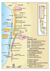
Location of Algarrobo and Salvadora projects.
Figure 2
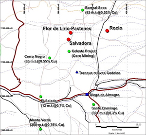
Location map showing the La Salvadora Project as well as major projects and operationsin the region.
Figure 3
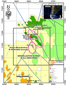
Location of the two target areas and drill holes at La Salvadora Project .
Figure 4
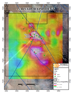
Chargeability map of a portion of La Salvadora showing SLVA-RC-0010 on the southern magnetic-Chargeability anomaly. The series of white historical RC drill holes show the distribution of near-surface copper oxide mineralization.
Figure 5
Algarrobo geophysical target drilling, drill hole location map.
2022 GlobeNewswire, Inc., source


