(via TheNewswire)
 | |||||||||
 |  |  | |||||||
Highlights
-Final results from Hi-tech full tensor ultrasensitive magnetic survey received.
-The system appears to successfully map the LCT pegmatite dykes, illustrating that there may be a wider and longer system ofanastomosingdykes than previously thought.
-Signatures up to 100 m wide.
-Drilling and channel samples confirmed multiple 1% LiOdyke intervals over 1 m width with coincident elevated Ta, Sn, and Cs values.
Historic soil sampling in a heavily treed area in the southeastern part of the property identified coincident Li, Ta, Sn, and Cs values. The QMAGT system identified a large vertical magnetic gradient anomaly (
Alpha Prime ) coincident with the soil anomaly.-The drill program planned for August and is already permitted.
QMAGT System
The QMAGT system is a helicopter-borne magnetic survey system utilizing a SQUID (superconducting quantum interference device) sensor measures the complete gradient tensor of the earth’s magnetic field. The SQUID sensors are developed by
Vertical Gradient Results and Interpretation
Figure 1 shows a colored grid map of the Bzz data channel from the survey, the left image is colored, so the zones of high gradient are the “hot” red colors, the right image is colored by reversing the palette so that the zones of low gradient are the “hot” red colors. The current thinking is that the LCT pegmatites have very little magnetic response, so they are the zones of low gradient, whereas when they were intruded into the surrounding sandstones, a hornfels was formed causing the high vertical gradients. The red colors in the right image of Figure 1 thought to map directly the LCT pegmatite dykes. It is an exciting result. Other vectors like Bxy (not shown) support this interpretation with coincident anomalies matching the reds in the reverse color image for Bzz. The results show a dense swarm of pegmatites, tens of metres across near northern drill holes. Drill hole MAC06 encountered 17.96 m of LCT pegmatite grading 1.03% LiO2and drill MAC07 drilled from the same site at a 60° dip encountered 10.94 m of LCT pegmatite grading 1.47% LiO2(Figure 2). In Figure 1 a strong LCT pegmatite response can be seen semi-continuous over the entire property measuring approximately 100 m across over many kilometres. Close inspection of nearby historic collars suggest they drilled near but above this target. One of the first tasks for our field crews this summer will be to ground truth these anomalies.
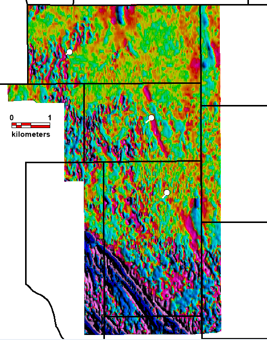
Click Image To View Full Size
Figure 1 (Left Image):Bzz (Measured vertical Gradient) flown over the center portion of the LNPG project in the NWT near the
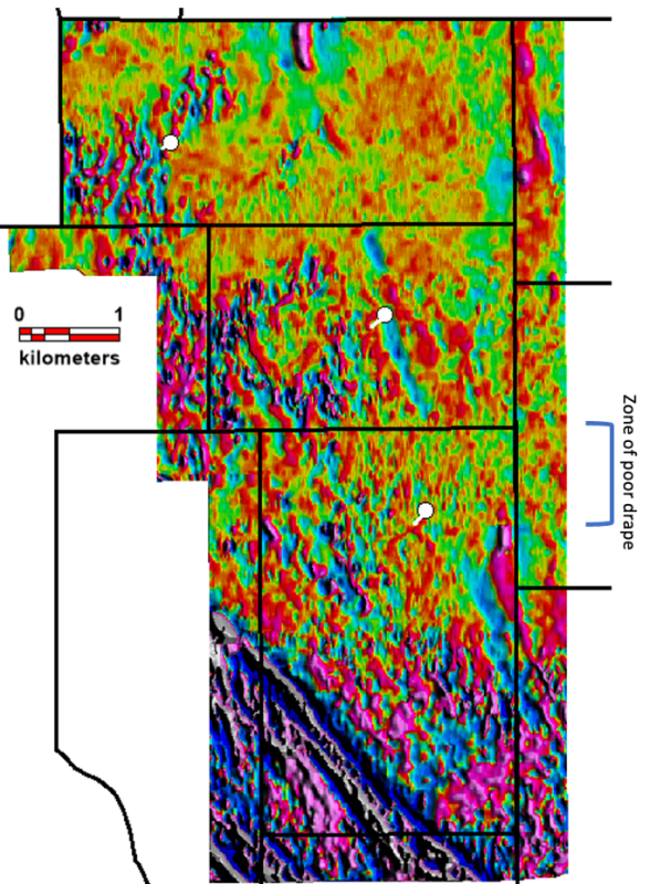
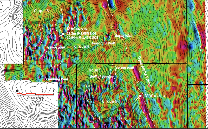
Figure 2 illustrates the northern part of the surveyed area, around drill holes MAC 06 and 07, with the reverse-colored image from Figure 1 (Right Image) and overlain by topographic contours. It is clear from the contours where there are deep cirque valleys a couple of hundred metres deep the helicopter was not able to drape and follow the terrain, making the distance from ground to sensor greater and the image gets “washed” out with less detail. The interpreted LCT pegmatite dykes have been traced out with lines of white dots. They seem to get cut-off by the cirques, but we know from outcrop they persist in the cliff faces of the cirques. The apparent cut-off is due to loss of sensitivity due to the height above the ground. Signal drops off at the square of the distance. On the upper plateau, a swarm of anastomosing dykes can be perceived including the dyke that was sampled by MAC 06 and 07. Part of the summer field program plan is to expand on the intercepts in these holes using 50 m step outs. This magnetic data will aid in locating these collars.
Click Image To View Full Size
Figure 2 A zoomed in view of the NW part of the property, with the Bzz data, reverse colors, with 5 m topographic contours. The red linears are thought to map out the LCT pegmatite dykes. Note the swarm near historic drill holes MAC06 and MAC07, at which these drill holes only test one dyke in the swarm. The channel sample highlights are shown in Table 1, below.
In the past field crews sampled the exposed pegmatite outcrop in the faces of the cliffs that define the cirques, the cliff faces were given colloquial names after famous “walls.” Table 1 lists the channel samples from the various cliff faces sampled. The small dykes sampled in Table 1 would not be able to be resolved in the magnetic data due to the small width, only the larger dykes and the combined swarms will show. Refer to Figure 2 for locations. The dyke swarm seems to continue in the magnetic data to the south past Cirque 6 in an unexplored part of the property. Figure 2 also illustrates an 80 m to 100m wide magnetic signature that traverses the entire data set for several kilometers. This anomaly has been named
Table 1: Channel sample results
Cliff face name | Width (m)*1 | Li2O (%) | Ta2O5(g/t) | SnO2(%) |
Prison Wall | 4.40 | 1.12 | 55.0 | 0.05 |
1.20 | 2.33 | 59.0 | 0.05 | |
1.90 | 0.87 | 56.4 | 0.03 | |
1.70 | 1.57 | 250.3 | 0.95 | |
Berlin Wall | 4.00 | 2.04 | 57.8 | 0.05 |
1.95 | 2.29 | 48.7 | 0.01 | |
0.95 | 3.10 | 53.6 | 0.03 | |
Great Wall of | 16.65 | 1.21 | 65.4 | 0.03 |
3.75 | 1.67 | 45 | 0.03 | |
7.00 | 1.41 | 59.9 | 0.04 | |
1.25 | 1.83 | 67.3 | 0.05 | |
5.15 | 1.63 | 52.9 | 0.01 | |
Hadrian’s Wall | 1.05 | 0.85 | 80.9 | 0.05 |
6.30 | 1.86 | 116.7 | 0.05 |
*1 – Measured widths are estimated to be 98 to 90% of the true thickness, due to the near vertical dip.
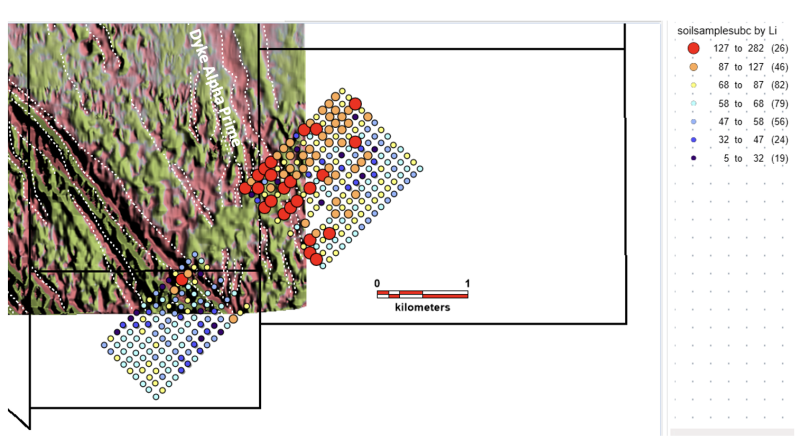
2006-2007 Soil sampling correspondence with the southern extent
The concept that the Alpha Prime dyke, is part of the LCT pegmatite swarm, is supported by soil sampling undertaken in the south end of the property in 2006 and 2007. These soil surveys used two assay methods, one with Aqua Regia for a selected digest, and one using four-acid near total digest. Lithium was only assayed for in the near total digest. Figure 3 shows the results of this work. The trace of
Click Image To View Full Size
Figure 3SW portion of the QMAGT survey, colors changed (to pastel purple) to highlight the soil geo-chem results associated with the pegmatite swarm. The Alpha Prime dyke signature is prominent and named in the figure. Each dot represents a soil sample site, the dots have been colored by Li ppm results as shown in the legend.
Soil sampling seems to be an effective tool in this environment, and there are plans to expand this soil grid in key areas of interest, to follow
Lake Winn is currently in planning with our consultants,
The technical information in this news release has been approved by
About Lake Winn
On Behalf of the Board of Directors of
CEO and Director
Telephone: (604) 218-8772
“Neither TSX Venture Exchange nor its Regulation Services Provider (as that term is defined in the policies of the
Copyright (c) 2023 TheNewswire - All rights reserved.
Copyright (c) 2023 TheNewswire - All rights reserved., source


