Highlights include:
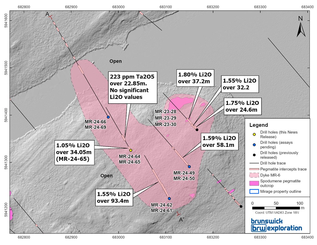
- Best interval to date at Mirage with 1.55% Li2O over 93.45 meters in drill hole MR-24-62 starting at surface and which extends the flat dipping MR-6 dyke a further 80 meters to the south-west.
- The MR-6 dyke was also extended 135 meters to the north of MR-24-62 where BRW intersected 1.05% Li2O over 34.05 meters in drill hole MR-24-65.
- MR-6 has now been drill traced over 220 meters of strike extent with real thickness varying from 25 meters and up to 70 meters. The dyke remains open in multiple directions with the strongest potential to the northeast and southwest.
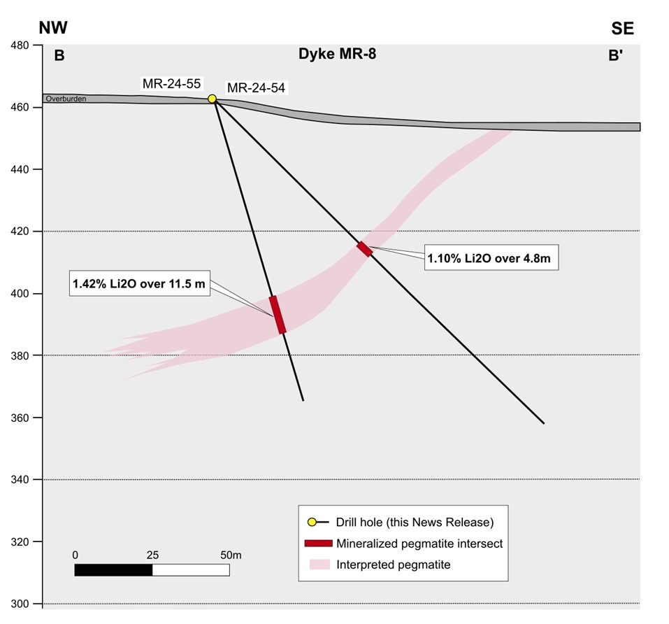
- New MR-8 dyke confirmed in the North zone with 1.27% Li2O over 18.6 meters in drill hole MR-24-43 and 1.42% Li2O over 11.5 meters in drill hole MR-24-55.
- New exploration drill hole located approximately 800 meters northeast of MR-6 intersected anomalous lithium values in drill hole MR-24-53 within a zone of dykes stacking. With this hole, BRW continues to extend the central corridor of prospective dykes towards another spodumene bearing outcrop located 3.5 kilometers to the northeast.
- A total of 26 drills holes results were received to date and 9 drills holes results style pending.
Mr.
Figure 1: Surface Map of the
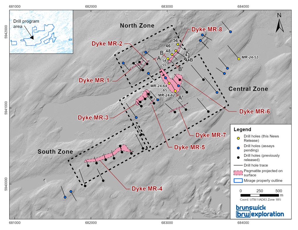
Table 1: Highlights from 2024 Winter Drilling Program Mentioned in this Release
| Hole ID | Zone | Dyke | From (m) | To (m) | Length (m) | Li2O% | Ta2O5 (ppm) |
| MR-24-43 | North | MR-8 | 9.85 | 28.45 | 18.6 | 1.27 | 81 |
| and | 83.95 | 86.7 | 2.75 | 0.99 | 101 | ||
| MR-24-44B | 14.4 | 31 | 16.6 | 0.95 | 81 | ||
| MR-24-46 | 35.4 | 52 | 16.6 | 0.87 | 97 | ||
| MR-24-48 | 43 | 61.5 | 18.5 | 0.80 | 93 | ||
| MR-24-53 | 225 | 227.2 | 2.2 | 0.55 | 143 | ||
| and | 251 | 274 | 23 | 0.33 | 95 | ||
| MR-24-54 | North | MR-8 | 66.55 | 71.35 | 4.8 | 1.10 | 198 |
| MR-24-55 | 67.6 | 79.1 | 11.5 | 1.42 | 166 | ||
| MR-24-56 | 49.05 | 59 | 9.95 | 0.32 | 44 | ||
| MR-24-62 | Central | MR-6 | 6.35 | 99.8 | 93.45 | 1.55 | 160 |
| MR-24-64 | 55.45 | 78.3 | 22.85 | N/A | 223 | ||
| MR-24-65 | 44.4 | 78.45 | 34.05 | 1.05 | 125 |
Figure 2:
Mirage Project Drilling Overview
There is potential to extend MR-6 to the east where it remains open towards the MR-3 dyke. The MR-3 dyke, located 350 meters southeast of MR-6 in the
Potential to extend
Figure 3: Cross Sections A to A’
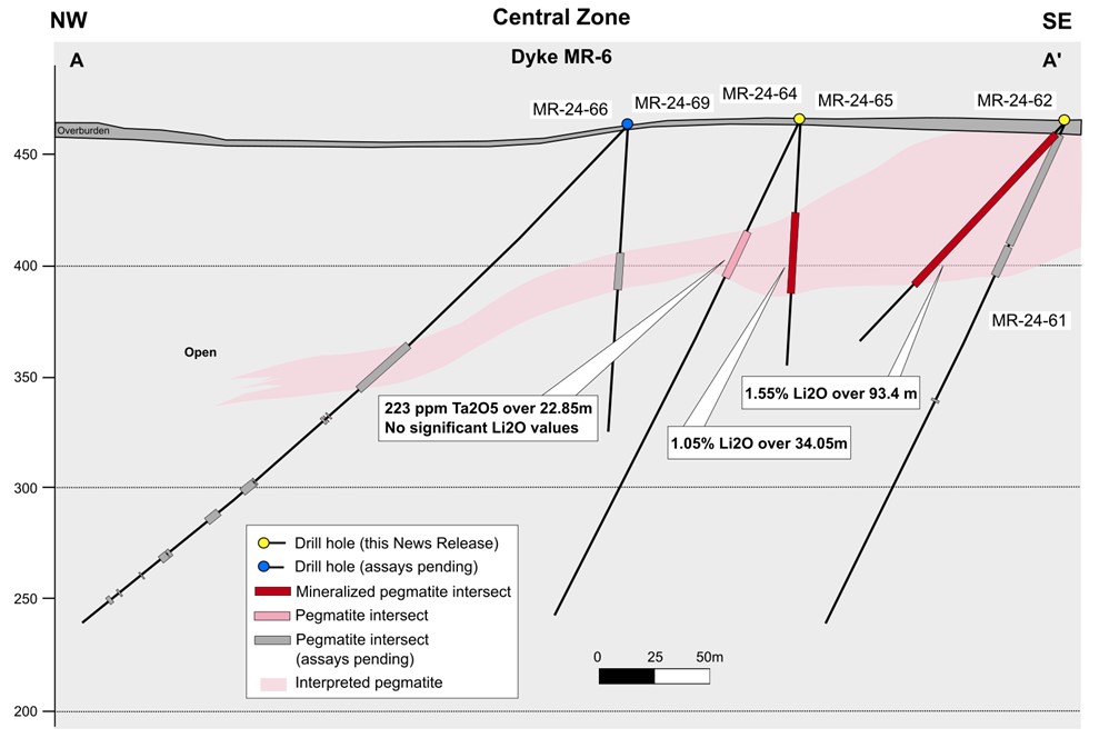
Figure 4: Surface map project of the MR-8 dyke

Figure 5: Cross Sections B to B’
QAQC
All drill core samples were collected under the supervision of BRW employees and contractors. The drill core was transported by helicopter and by truck from the drill platform to the core logging facility in Val-d’Or. Each core was then logged, photographed, tagged, and split by diamond saw before being sampled. All pegmatite intervals were sampled at approximately 1m intervals to ensure representativity. Samples were bagged; Duplicated on ¼ core splits, blanks and certified reference materials for lithium were inserted every 20 samples. Samples were bagged and groups of samples were placed in larger bags, sealed with numbered tags, in order to maintain a chain of custody. The sample bags were transported from the BRW contractor facility to the ALS laboratory in Val-d’Or. All sample preparation and analytical work was performed by ALS by ICP-AES according to the ALS method ME-MS89L. All results passed the QA/QC screening at the lab and all inserted standard and blanks returned results that were within acceptable limits. All reported drill intersections are calculated based on a lower cutoff grade of 0.3% Li2O, with maximum internal dilution of 5 meter. Host basalts adjacent to the dykes may grade up to 0.3% Li2O but were excluded from the reported intersections.
Qualified Person
The scientific and technical information contained in this press release has been reviewed and approved by Mr.
About
Investor Relations/information
Mr.
Cautionary Statement on Forward-Looking Information
This news release contains "forward-looking information" within the meaning of applicable Canadian securities legislation based on expectations, estimates and projections as at the date of this news release. Forward-looking information involves risks, uncertainties and other factors that could cause actual events, results, performance, prospects and opportunities to differ materially from those expressed or implied by such forward-looking information. Factors that could cause actual results to differ materially from such forward-looking information include, but are not limited to, delays in obtaining or failures to obtain required governmental, environmental or other project approvals; uncertainties relating to the availability and costs of financing needed in the future; changes in equity markets; inflation; fluctuations in commodity prices; delays in the development of projects; the other risks involved in the mineral exploration and development industry; and those risks set out in the Corporation’s public documents filed on SEDAR at www.sedar.com. Although the Corporation believes that the assumptions and factors used in preparing the forward-looking information in this news release are reasonable, undue reliance should not be placed on such information, which only applies as of the date of this news release, and no assurance can be given that such events will occur in the disclosed time frames or at all. The Corporation disclaims any intention or obligation to update or revise any forward-looking information, whether as a result of new information, future events or otherwise, other than as required by law. Neither the
Photos accompanying this announcement are available at:
https://www.globenewswire.com/NewsRoom/AttachmentNg/aa294aec-674f-4a4e-bccb-d053c3f7293e
https://www.globenewswire.com/NewsRoom/AttachmentNg/ee011d06-b489-43d8-805c-4e95c80eaaa5
https://www.globenewswire.com/NewsRoom/AttachmentNg/df469017-f568-4a52-8380-ae4fd4cbf96c
https://www.globenewswire.com/NewsRoom/AttachmentNg/c957a2f9-3ffe-4dee-9c0b-15c0d52021e1
https://www.globenewswire.com/NewsRoom/AttachmentNg/facdce54-70b8-46c1-bd94-64dd3b8edc1d

![]()
Figure 1:
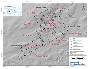
Surface Map of the Mirage Project and Drill Holes Completed to Date
Figure 2:

Central Zone of the Mirage Project
Figure 3:

Cross Sections A to A’
Figure 4:
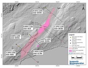
Surface map project of the MR-8 dyke
Figure 5:

Cross Sections B to B’
2024 GlobeNewswire, Inc., source

